Scientists have found what they believe to be old Wampanoag burials throughout the area known as Burying Hill, after deploying ground-penetrating radar starting in mid-April.
May 7, 2025
Tribal graves detected on Burying Hill in Bourne. 3D map to be drawn.
BOURNE — Scientists have found what they believe to be old Wampanoag burials throughout the area known as Burying Hill, after deploying ground-penetrating radar starting in mid-April.
The burials are relatively shallow so they are easy to confuse with tree roots, said John Steinberg, a research scientist with the Fiske Center for Archaeological Research at the University of Massachusetts Boston. “But we think we know where some of them are.”
The project confirms what tribe members have known for centuries through oral tradition — that Wampanoag ancestors were buried there, said Herring Pond tribal elder Hazel Currence.
“This brings a great awareness about our original communities to the greater population,” said Currence. “About who we were, who we are, and why we are trying to protect our homeland, our way of life, and our traditions and culture.”
On Saturday, May 3, Steinberg and his team, along with about 20 Herring Pond Wampanoag Tribe members gathered at Burying Hill, to learn about the possible 50 burials that Steinberg located by sending radar waves through the soil.
Steinberg, who has been working on the site since April 15, guided tribal citizens through his research and showed them how to use radar receivers, and transmitters.
The project — a partnership between the university, the town of Bourne, and the tribe, is funded with Community Preservation Act money approved at the 2024 fall town meeting.
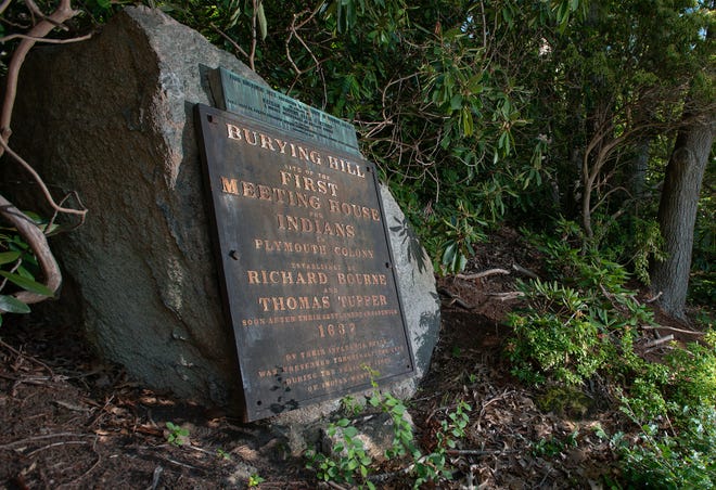
Burying Hill, on a rise above the Cape Cod Canal, was a traditional burying ground of the Wampanoag Nation and may have been used earlier than the 17th century, said Herring Pond Tribe member and attorney Jamie Hoctor. Burying Hill is also the likely site of the tribe’s first meeting house, Hoctor said.
Chiara Torvini, with UMASS Boston, gives a demonstration of a ground penetrating radar device that has been used in an archaeo-geophysical investigation of the Wampanoag Burying Hill area in Bournedale.
Photo Taken on May 3, 2025
Homelands for the Herring Pond Wampanoag Tribe range from Plymouth to nearby Cape towns of Bourne and Sandwich. The tribe, headquartered in Plymouth, was granted state recognition in November. There are about 200 active tribal citizens.
Where on Burying Hill are the remains?
The location of the burials will remain confidential, said Steinberg.
“We don’t want to reveal unmarked graves. It’s illegal. And our client — the tribe ― is interested in protecting the burial grounds,” he said.
Steinberg hypothesized that the tribe’s ancestors were positioned on their sides at the time of their burial—their bodies wrapped in a shroud or some kind of blanket.
“This is not like a Christian burial ground. These guys are really hard to find. There’s no coffins and in most cases there’s no markers,” said Steinberg.
Steinberg has detected similar burials before using ground penetrating radar at both the Old Indian Burial Grounds in Bourne, and within an ancient Viking burying ground in Iceland.
At Burying Hill, said Steinberg, the burials will remain undisturbed.
The team, he said, is also looking for evidence of the meetinghouse that once stood at the top of Burying Hill.
“So far we haven’t found evidence of the meetinghouse but we will keep looking,” he said.
What prompted the project?
Hoctor and Kerina Silva, also an attorney and Herring Pond Wampanoag tribal citizen, have been researching the town-owned Burying Hill since December 2023, after appealing an order of resource area delineation filed in November 2023 with the Bourne Conservation Commission by property owner Steven Kahian.
Kahian told the Times on Tuesday that he intends to donate 1.06 acres of his land to the tribe.
Before the land is officially transferred, Kahian said he needs to gain approval from other town boards and committees. But he said engineering plans and an agreement were put on record during the Thursday, May 1, Bourne Conservation Commission hearing.
“I could’ve been a real jerk and sat on it and did nothing with it,” Kahian said of his land. “Instead, this is the best use of the land. It’s respect for the land.”
The engineering map shows a pathway that Kahian intends to build that will wrap around the property, the waterfront and the herring run, to allow tribal members access to Burying Hill, Silva said. She attended the May 1 meeting.
“The commission, and the tribal members who were present at that meeting were very impressed and happy with his plans,” she said. “This is an example of the good that can happen when the town, private citizens, and the tribe work together and share our history.”
How does the radar work?
The radar includes an antennae, receiver, and data collector and sends waves through the soil and then measures the amount of energy as it returns, and the amount of time it takes to receive it, said Steinberg.
Because radar waves travel at different speeds throughout different materials, scientists can use the measurements to identify whether an object below the ground is different from the soil around it, said Steinberg. A common difference is the amount of water in the soil, he said, and the radar waves travel fast through air and more slowly through wet ground.
“Lucky for us, the shafts (the excavated hole) and more often bones generally hold more water,” said Steinberg.
A difference or contrast in what’s under the ground can cause a reflection (or distorted light) in the data, said Steinberg. The radar can’t identify with 100% certainty what causes a reflection, he said. However there are certain characteristics of reflections that are consistent with burial shafts, according to Steinberg.
Herring Pond Wampanoag tribal citizen Jackie Saltalamacchia said she was able to conduct some of the ground penetrating radar. It’s been exciting, she said, to be able to hypothesize about tribal ancestors.
“In some ways I have more questions than I have answers. But it feels good to sit out here and dream of what this research can show and what we can figure out about our people,” she said.
What’s next for Burying Hill?
Eventually, through additional research, said Steinberg, a map will be created to identify whether the remains were buried in clusters, or if they were evenly spaced. At this point in the project, he said, the raw data will continue to be collected and analyzed through May 15. The team will eventually use the data to create a 3D image of the subsurface.
For Herring Pond Wampanoag Tribe Chairwoman Melissa Ferretti, the project isn’t just about uncovering the past, it’s about honoring the stories and lives of those that rest on Burying Hill.